Hello all,
I've recently purchased OWM in order to design a map for a board game. I also took a look at Campaign Cartographer, but OWM looked a bit more modern so chose to purchase that instead.
The map I wanted to create is set in Ancient Rome so I followed this great tutorial to import data from Natural Earth https://www.otherworldmapper.com/blog/t ... -data-shp/
I'd like to say thank you for the support on the forum and blog post to help create this map. Here's the finished result.
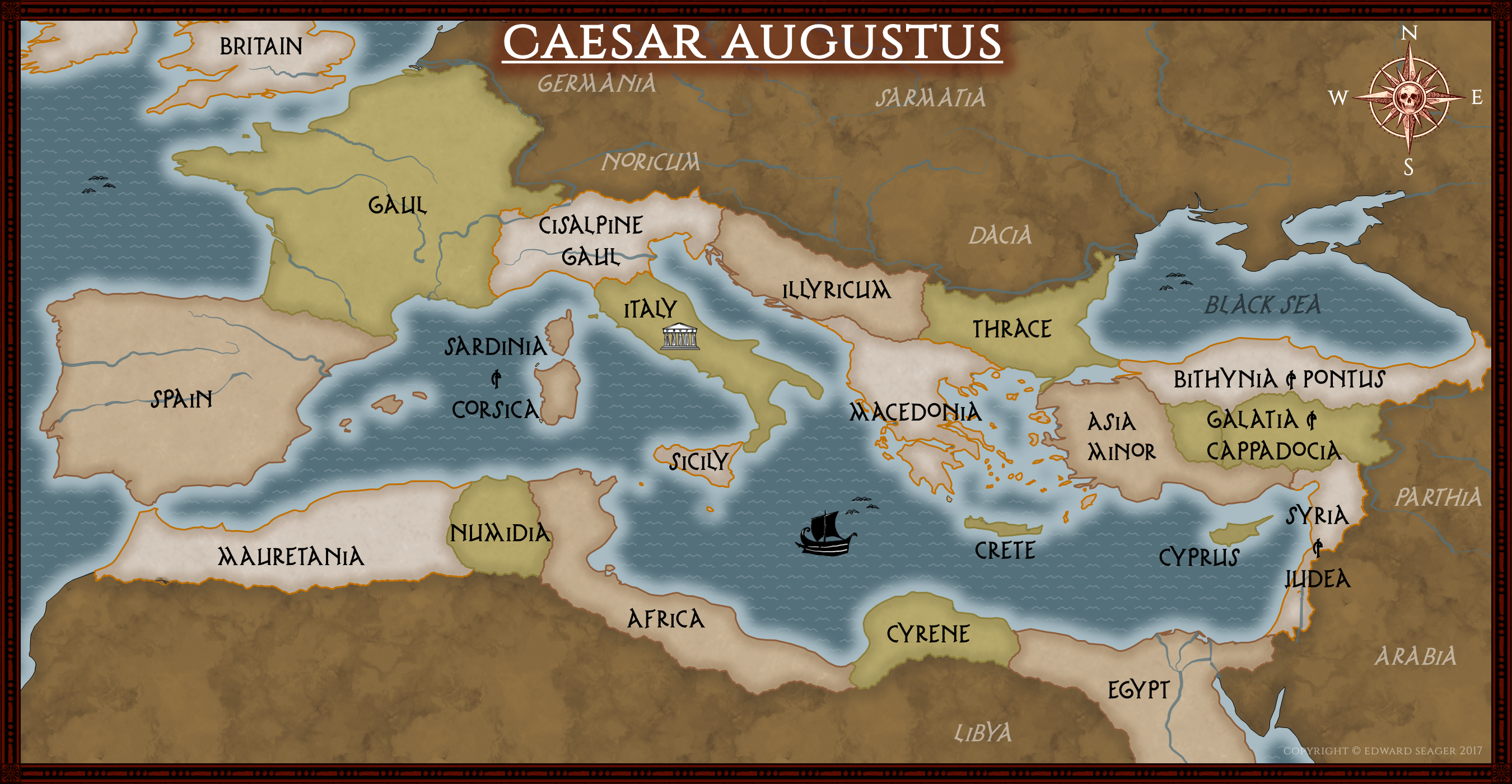
I found it very easy to change the colours and textures on OWM. What was more tricky, was resizing it down to just the Mediterranean section. I ended up copying and pasting the map into a smaller canvas but as a result, I have a lot of the world hidden outside the canvas which makes it a bit tricky to work with.
I'm also not sure how to move some of the boarders which I created with the partition tool. It seems there are an enormous amount of datapoints and moving individual points will not have the desired affect.
One suggestion I have for artwork is to have some seamonsters like you see on old maps.. like this kind of thing https://www.smithsonianmag.com/science- ... s-1805646/
I'd be interested to know if other users have had similar experiences trying to create maps based upon real world data.
Thanks for taking the time to read my post.
Hello from Manchester UK
Moderator: Kanchou
Re: Hello from Manchester UK
Sorry for the late reply and you are quite welcome! Glad we were able to help - and your feedback and questions help us make our tutorial better (or more of them) and fix issues with OWM. So thank *you*!
Also, that map looks Awesome! . When you are ready, and if you want, we would be happy to share your project on our FB, etc.
Now for answers:
- Alejandro
Also, that map looks Awesome! . When you are ready, and if you want, we would be happy to share your project on our FB, etc.
Now for answers:
Can you give us a bit more detail? Would love to be able to address what's giving you trouble in our next release.tarski wrote:What was more tricky, was resizing it down to just the Mediterranean section. I ended up copying and pasting the map into a smaller canvas but as a result, I have a lot of the world hidden outside the canvas which makes it a bit tricky to work with.
You can move individual points, but also you can drag "control points" that drag entire segments. Is that what you were going after?tarski wrote: I'm also not sure how to move some of the boarders which I created with the partition tool. It seems there are an enormous amount of datapoints and moving individual points will not have the desired affect.
We're about to start adding artpacks to our website, so we'll take that request for future packs . And as always, OWM is open for you to import your own artwork - so it's not limited to ours.tarski wrote: One suggestion I have for artwork is to have some seamonsters like you see on old maps.. like this kind of thing https://www.smithsonianmag.com/science- ... s-1805646/
- Alejandro
Alejandro S. Canosa
Three Minds Software
Re: Hello from Manchester UK
Hello back from London UK, Tarski!
Your board game map looks impressive.
David "Big Mac" Shepheard
(A Spelljammer fan hoping to user Other World Mapper to make lots of maps of planets.)
You can see more of me over at The Piazza campaign settings forums
(A Spelljammer fan hoping to user Other World Mapper to make lots of maps of planets.)
You can see more of me over at The Piazza campaign settings forums
Re: Hello from Manchester UK
Thanks, you are both very kind. It would be awesome if you could feature me on FB when my project is a bit more mature.
One thing I mentioned on another thread was an issue with merging two areas which had been partitioned. When I took the union of Galatia and Cappadocia, I was left with this hole in it (those poor Roman's must have drowned!)
If you like, I can send the map to your team if it will aid in debugging the problem?
Now that you mention it, I found it quite easy to pull one of the points out using the transform tool. It was very easy to do so - no problem thereYou can move individual points, but also you can drag "control points" that drag entire segments. Is that what you were going after?
I'm not sure how to describe it really... basically I wanted to take the world map from Natural Earth and crop it down to only the Mediterranean. I couldn't find an easy way to crop an area, like in Paint I would just draw a box around it. So I had to copy it into a new canvas which was smaller and move it around a bit, but there is a large area of the map hidden off the canvas. Perhaps this isn't an issue... what was tricky was actually using the partition tool around the edge the map (e.g. the bottom of Egypt) because there is no snap to edge option for that tool, unlike landmasses.What was more tricky, was resizing it down to just the Mediterranean section. I ended up copying and pasting the map into a smaller canvas but as a result, I have a lot of the world hidden outside the canvas which makes it a bit tricky to work with.
One thing I mentioned on another thread was an issue with merging two areas which had been partitioned. When I took the union of Galatia and Cappadocia, I was left with this hole in it (those poor Roman's must have drowned!)
If you like, I can send the map to your team if it will aid in debugging the problem?
Re: Hello from Manchester UK
On the first part, I think it would make sense to add a crop tool - or have a crop option for the partition tool so you don't have to manually use the partition tool to crop each shape. We'll see what we can do.tarski wrote:
I'm not sure how to describe it really... basically I wanted to take the world map from Natural Earth and crop it down to only the Mediterranean. I couldn't find an easy way to crop an area, like in Paint I would just draw a box around it. So I had to copy it into a new canvas which was smaller and move it around a bit, but there is a large area of the map hidden off the canvas. Perhaps this isn't an issue... what was tricky was actually using the partition tool around the edge the map (e.g. the bottom of Egypt) because there is no snap to edge option for that tool, unlike landmasses.
hole.png
One thing I mentioned on another thread was an issue with merging two areas which had been partitioned. When I took the union of Galatia and Cappadocia, I was left with this hole in it (those poor Roman's must have drowned!)
If you like, I can send the map to your team if it will aid in debugging the problem?
On the second part, if you can email us the map that would very helpful. info@threemindssoftware.com
Boolean operations have a couple of issues left, particularly complicated fractal shapes.
Thank you!
- Alejandro
Alejandro S. Canosa
Three Minds Software