Questions and comments about Other World Mapper.
Moderator: Kanchou
-
Lionheart
- Posts: 26
- Joined: Tue Jan 09, 2018 3:10 pm
Post
by Lionheart » Tue Jan 26, 2021 7:49 pm
Simplifying my questions:
What does the suggested mile to pixel setting do (seen when creating a new map)? The suggested standard opening the program is 1 mile = 100 pixels. What does it do?
Am I missing how I can add a ruler showing me the distances based on original settings? The only work around I have found is to use the measure tool to get the number of inches and then calculate myself. The rulers you can add has no mile setting that automatically updates. Is there a way to add a scale ruler to the map that shows the scale based on my settings (miles pr. pixels)?
The setting:
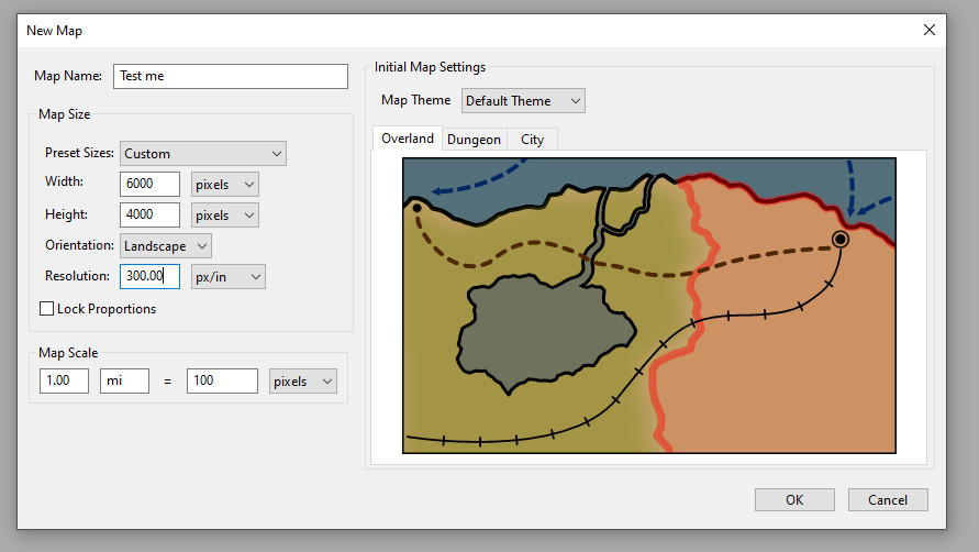
Also if I created a map that is 6000 pixels wide, that would make it just 60 miles across if I choose the suggested 1 mile = 100 pixels.
Hmm..
Last edited by
Lionheart on Wed Jan 27, 2021 9:52 pm, edited 2 times in total.
-
Kyete
- Site Moderator
- Posts: 237
- Joined: Tue Nov 11, 2014 4:52 pm
Post
by Kyete » Fri Jan 29, 2021 11:55 am
Hi,
At the moment, this setting is only used for the measure tool and ruler World Units options. We called it “world units” because the units are custom and could be anything. We are planning on adding a scale ruler that will use it, but things are going slower than planned and it had to be pushed back.
The Map Scale from a new map is just a default, so if you are making a larger map you would want to adjust it accordingly.
-Katie
-
Lionheart
- Posts: 26
- Joined: Tue Jan 09, 2018 3:10 pm
Post
by Lionheart » Fri Jan 29, 2021 12:34 pm
Hi
That's great. I totally missed the "world units" part of the ruler. Makes it a lot easier to make a scale ruler for the map! Perfect.
I also hadn't noticed I could measure a total landmass in square miles / world units. That's great. I just keep learning new things.
Any chance you could open up about what sort of features you are planning for 2021?
Cheers
L.