I need a way to draw ocean currents for my climate maps. How would you go about it in OWM?
I would also like to draw arrows to mark dominant winds. Is this currently possible?
Arrows, currents and other markers
Moderator: Kyete

Re: Arrows, currents and other markers
Stefan,
* Even though it wasn't part of the KS, we are planning on adding common vector shapes tool (arrows, dots, etc). That should cover the second point.
* We had plans to weather related tools for subsequent versions of the software, but can you post some links to the general look and feel you are looking for? We may be able to add something within existing functionality.
Thanks again!
- Alejandro
Alejandro S. Canosa
Three Minds Software
Three Minds Software
Re: Arrows, currents and other markers
Awesome! I would much rather use big dots for cities in most of my maps, anyway.Kanchou wrote:Stefan,
* Even though it wasn't part of the KS, we are planning on adding common vector shapes tool (arrows, dots, etc). That should cover the second point.
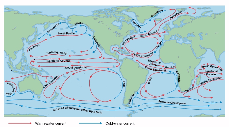
For a basic drawing of ocean currents, I was thinking something like this:* We had plans to weather related tools for subsequent versions of the software, but can you post some links to the general look and feel you are looking for? We may be able to add something within existing functionality.
If you could find a way to make creating something like the below easy, that would be even more awesome, but is not necessary for me to be happy:

Another thing I need for climate maps are temperature zones and Koppen climate zones. It can be more or less solved with existing tools, though.
Re: Arrows, currents and other markers
Stefan,
The first example you could get with the searoute tool, I think. If made into its own tool based on the sea routes, would that work?
The second example from a coding point of view seems pretty similar to the first. It's mostly allowing wider segments and along the path arrows. Would those two things work?
Let us know and we'll see where we can fit in the schedule.
- Alejandro
Alejandro S. Canosa
Three Minds Software
Three Minds Software
Re: Arrows, currents and other markers
We talked about several changes, so I wanted to make sure you didn't miss my previous reply. What do you think? That's something we could probably fit into the schedule.stefanstr wrote: For a basic drawing of ocean currents
Thanks!
- Alejandro
Alejandro S. Canosa
Three Minds Software
Three Minds Software
Re: Arrows, currents and other markers
Hmm, I remember writing a response to this days ago. Maybe I never clicked “Submit” and unwittingly closed the tab.
The only problem I see with the sea route tool is that it seems to need to snap to a shore. (Or does my memory fail me? I have no access to the Windows machine right now.) Ocean currents’ arrows can end anywhere. But if you allow for that and add actual arrows, a tool based on the sea route tool would work well enough. (And I don’t think you should call it “currents” but simply “arrow tool” - I can see it being very useful for drawing war campaigns, for example.)
And yes, an arrow tool with adjustable segment width would be all I need.
Re: Arrows, currents and other markers
Generic arrows and other vector based symbols will be added with Beta 2 (maybe 1?) so that would work perfectlystefanstr wrote:Hmm, I remember writing a response to this days ago. Maybe I never clicked “Submit” and unwittingly closed the tab.
The only problem I see with the sea route tool is that it seems to need to snap to a shore. (Or does my memory fail me? I have no access to the Windows machine right now.) Ocean currents’ arrows can end anywhere. But if you allow for that and add actual arrows, a tool based on the sea route tool would work well enough. (And I don’t think you should call it “currents” but simply “arrow tool” - I can see it being very useful for drawing war campaigns, for example.)
And yes, an arrow tool with adjustable segment width would be all I need.
Thanks!
- Alejandro
Alejandro S. Canosa
Three Minds Software
Three Minds Software